Showing posts with label Netherlands. Show all posts

Tuesday, March 4, 2014

Monitoring the Water Level


As we left the Zuiderzee Museum on our way to Amsterdam, we had a chance to reflect in the bus about the challenges of the sea. As we learned while entering the country, the Netherlands is flat with relatively few differences in altitude. In fact, over half of the country is below sea level. Fortunately, there are dunes, dikes, and other forms of protection to make sure the Netherlands is not flooded.

To find out if the dunes and dikes are still high enough to prevent water damage, measurements are made on a regular basis of the levels of land and water. A water-level gauge is an instrument to measure the level of surface water, for example. and we've been noticing these the past couple of days.


The best-known in the Netherlands is the so-called NAP gauge (shown above on the shores of the Zuiderzee Museum), which indicates the water level in rivers, ditches, and canals in relation to the Normaal Amsterdams Peil NAP (Normal Amsterdam Level). The NAP is the level of reference to which level measurements in the Netherlands are related. A zero NAP level is equal to the average sea level.


The highest point in the country is in the province of Limburg. In the town of Vaals, where Holland, Belgium, and Germany meet, it is at 322.5 meters (1,058 feet) above NAP. The lowest point, 6.76 meters (22 feet) below NAP, is in a field in the Zuidplas Polder in the vicinity of Nieuwerkerk aan den Ijssel. In that polder, the differences in altitude are quite visible, they say.

Lunch at the Zuiderzee


Lunch was on our own so after walking around the museum, which was frankly massive, Sam and I decided we better find our meeting place before selecting a place to eat. On our way to the small town, we walked pass some silly goats making good use of an abandoned boat next to a canal.

It was a beautiful, sunny, and comfortable day for a nice walk. And we wanted to eat on the "sunny side of the street" so we were looking for a cafĂ© with outdoor seating in the sun.


Lucky us because we found exactly what we wanted not too far from our meeting place. There was even a little draw bridge and Sam hoped to see it raised for a boat to sail through.


I had another "pancake" with apples and bacon and Sam chose a very colorful and hearty-looking salad.


Truth be told, I'm all about the syrup and the powdered sugar!


Our patience finally paid off. Before we finished eating, we noticed the bridge spans begin to separate and rise up. And although our photos didn't successfully show the boats (they were low in the water), we were treated with seeing one or two of their sails pass by.

 
And we weren't the only ones enjoying the view and snapping photos. But now, we better get to the bus!

Hello to the Flower Market

 
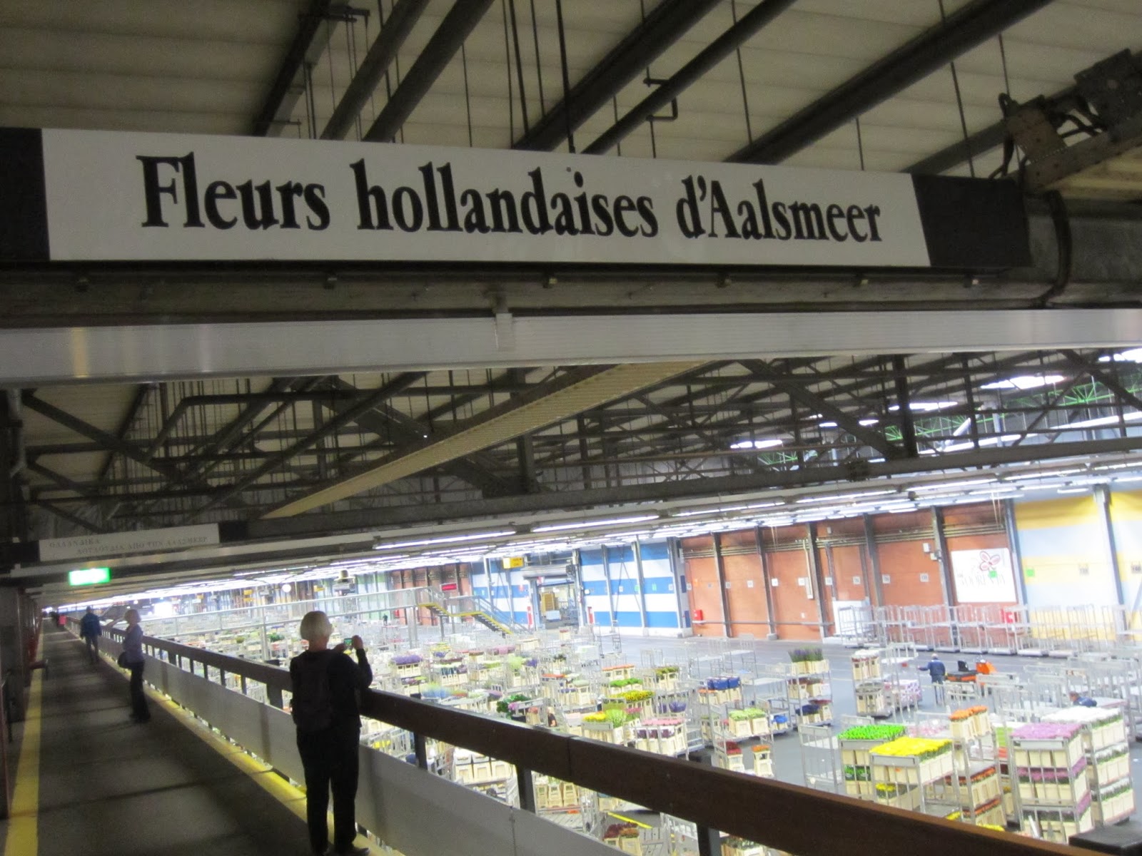
On our way to Amsterdam and about an hour out of Delft, we stopped at the FloraHolland Aalsmeer Flower Auction, which is close to Holland's largest airport, Schiphol. This vast auction warehouse--an international trading platform for flowers and plants--ships merchandise literally all over the world on the day it's sold.
 

While we waited for Dirk to park the bus, Hilbren explained the details of the auction. Covering 243 acres (Wikipedia says it's the largest "building by footprint in the world"), it opens very early every day and employs over 4,000 people. Flowers from all over the world (Europe, Ecuador, Columbia, Ethiopia, Kenya, etc.) are traded and more than 20 million are sold daily with a 15% increase around Valentine's Day and Mother's Day--over 12 billion a year! That adds up to 4.4 billion euros annually.


I wonder how many football fields would fit in here. Each section on the floor is numbered, like a stadium.


Traffic is hectic on the floor where all the plants and flowers are moved around the warehouse on pallets. Much of the their movement is automated on tracks running this way and that. In other areas, workers stand on a fork-lift type machine, like a Segway, pulling pallets to and from the auction. Sometimes, they use a type of hand cart to pull the pallets in and out of line. It is organized chaos! And quite incredible to watch.


Buyers enter the refrigerators and look at the goods, take notes on what they want, and may call a customer about bidding on a particular item.


It works the opposite of an auction in the United States. In other words, the prices start high and work their way down. Entering an early bid gets a buyer what he/she wants at the highest price.


The buyers sit in a theatre-style room--30 to a row, 10 rows deep, with everyone on a computer and wearing headphones. Pallets wind their way in and out of the room on those automated tracks, like slow-moving train cars. Buyers view and bid continuously and electronically.
 

Automated clocks are mounted on the wall (a total of 38 auction clocks) plus a photo of the flower or plant currently open for bids and other automated information. The bidders only get a few seconds to take action before the product makes its way out of the room and is shipped off. Bidding activities continue until everything is sold.


This photo was taken from the bus after leaving the flower market on our way to Amsterdam (so it's not one of my best)--fields and greenhouses along the way, growing all of these beautiful flowers which eventually make their way through the market headed to Schipol. It was an interesting and fun stop.

Monday, March 3, 2014

Maeslantkering Storm Surge Barrier and the Delta Project

Although this stop was a little mind-numbing for me--after all, we had been on and off the bus all day--I think the storm surge barrier was Sam's trip highlight. Hilbren had spent the day teaching us about the centuries-long struggle the Dutch have had with the seas. After the storm of 1953, they said "never again."
 

But the Netherlands exist in a low-lying Delta surrounded by water and the Port of Rotterdam must be accessible. So, how to solve the problem of and control storm surges? Six designs were submitted by companies within the Netherlands for the Delta Project--the barrier needed to be easy to maintain and not stop the flow of ships in and out of the port, even when there was fear of a surge. From those six companies, one was selected; and the barrier was installed in 1997.
 
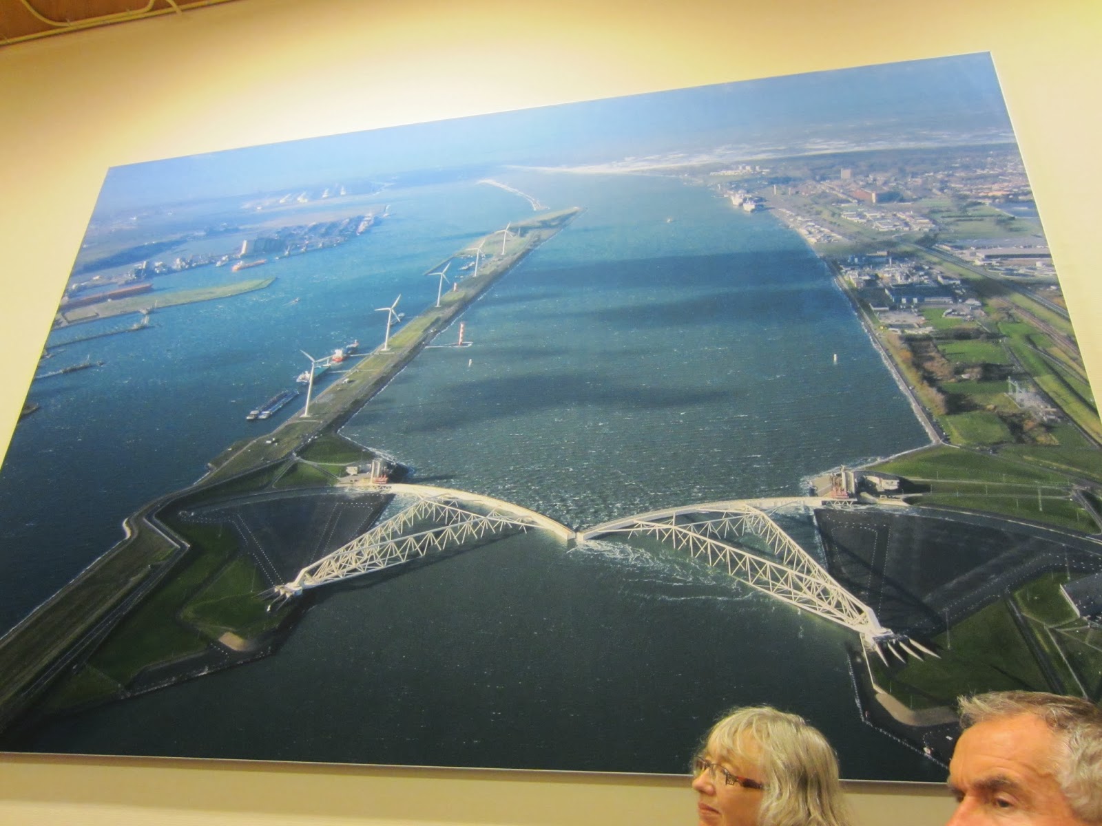
Our group entered a grey metal industrial-looking building--the Keringhuis Museum labeled "Publiekscentrum Water--it looked more like a warehouse than a museum. But it held some interesting surprises. The huge photos, colorful layouts, and interactive displays were very impressive--in fact, critical for most of us to understand the concept. The very informed young man who was our guide explained in detail the history and workings of the barrier before we walked outside in the grey and windy weather.


If I understood correctly, this is how it works. As water rises--signaling a surge--the storm gates also rise, then shut, sinking to the riverbed and forming walls of steel. When storm season is over, the gates, which are open, sit on the docks to avoid corrosion--like they were today.

Every year on September 21st, they test the storm barrier by closing it (top photo), which is viewed by thousands who come out to watch. It stays closed for 12 hours so it can be examined and maintained. Since a major storm is expected only once every 10,000 years, I guess we'll never know if it will actually work! But what a lesson about how the Dutch survive living below sea-level.

The North Sea and the Port of Rotterdam


Well, Sam can't say she got to wade in the North Sea but at least we took our shoes off and walked across the softest and finest sand ever!


Hilbren surprised us by a short detour and stop at the North Sea. Hmmm, have I ever been on the shores of the North Sea before? Maybe when I was in the Netherlands during my first trip here in 1989.


It was very windy and many wind surfers were out. The span of sand from where we were standing to the sea was probably a football-field away.


Next, we drove by the Port of Rotterdam, one of the main ports and the largest logistic and industrial hub of Europe. It is the gateway of more than 350 million consumers to the European market. And with an annual throughput of 450 tons of cargo in 2012, it is by far the largest seaport of Europe.


It seemed to go forever and ever.--which makes sense because the port stretches over 40 kilometers (25 miles) and is about 12,500 hectares (nearly 31,000 acres). Unfortunately, the photos of the port are not very exciting.

Rebuilt Town of Zierikzee


Rebuilt after the catastrophic 1953 North Sea Flood, we stopped in Zierikzee to wander in the sun and find some lunch. What a beautiful day it was; we were lucky on this trip as far as weather went. After Hilbren gave us an introduction, we were free to take off, snap some photos, and find a place for lunch.


The town fronting the water was all rebuild since the flood, even though they kept the style of the original buildings.


We love these old drawbridges (this one, not so old) which are all over the Netherlands.


Fish and chips for lunch along the waterfront. What could be better? They were delicious and I ate too much (including an ice cream cone)!


And here's where we had our group photo taken, in front of the village's windmill.

Back on the bus and then a surprise stop at the North Sea.

The Netherland's Watersnood Museum


About 20 minutes from Bruges, we left Belgium and entered the Netherlands at Zeeland (translation," sea land"). Most of the land--a collection of islands--lies below sea level and was reclaimed over time from the sea, rivers, and lakes by the Dutch. In the process, the shape of the landscape has changed at the hands of both man and nature.

That's where the famous windmills enter into the picture. After diking off large tracts of land below sea level, the Dutch used those to harness wind energy, lifting the water up out of the enclosed area, diverting it into canals, and draining the land--called polders. They then cultivated hardy plants--like barley, followed by wheat--to remove salt from the soil, slowing turning marshy estuaries into fertile farmland. The windmills later served a second purpose for farmers by turning stone wheels to grind their grain.

 
Dutch reclamation projects are essentially finished. But in this era of global warning and rising sea levels, the Dutch are developing plans to upgrade their dikes and bulk up their beaches to hold back the sea. They also continue to innovate, building floatable homes and greenhouses (which rise with the tides) and relocating dikes farther from the rivers (to create wider floodplains). All this technological tinkering with nature over the centuries translated into a popular local saying: "God made the Earth, but the Dutch made Holland."
 

We finally--we drove for a couple hours, including a wrong turn because of construction--arrived at the town of Zierikzee and found the Watersnood (Flood) Museum in Ouwerkerk. This museum displays exhibits from the natural disaster which took place on the night of January 31, 1953 when the dykes gave way for a night of incredible flooding and mass destruction. Hilbren's uncle lived here at the time and swam all night to survive. Afterwards, he moved to Canada and never wanted to return because his memories were so traumatic.


Besides being dedicated to the North Sea Flood of 1953, the museum--which is located inside four massive breakwaters or caissons which were used to plug the last gap in the dike here--also shows how the Netherlands works with and against water, The caissons were from England and originally intended for one of the Allied landings at Ostend in Belgium, which was never realized.


For that reason, it was very cold in here--a very large exhibition "hall" full of exhibits, maps, books, records of the deceased, interactive displays, etc. We could've spent many hours educating ourselves but we only had about 45 minutes, much of which was taken up by watching a movie prior to wandering through the caissons.


Tens of thousands had to flee their homes that night; and 1,800 people lost their lives. The dreadful night obviously caused sheer devastation. But since that time, the Dutch government and people have worked to ensure this type of disaster never happens again. It was extremely sobering to see some of the remnants from the destruction to peoples' lives.


Next, we were headed to the rebuilt town of Zierikzee because the original one was damaged by the 1953 catastrophe.

Entering the Netherlands


This morning's bus ride was long today as we left Belgium and entered the Netherlands. I like the way this photo taken from the bus focused on the little barge heading along the canal next to the road leaving Bruges.
 
In Holland's 17th century Golden Age, the tiny country (Holland is just a nickname for the Netherlands) was a world power--politically, economically, and culturally--with more great artists per square mile than any other country at that time. Today, it is Europe's most densely populated and also one of its wealthiest and best organized.
 
"Netherlands" means "lowlands" and the country occupies the low-lying delta near the mouth of three of Europe's large rivers. In medieval times, inhabitants built a system of earthen dikes to protect their land from flooding caused by tides and storm surges. But in 1953, as we were to find out, severe floods breached the old dikes, killing 1,800 and requiring a major overhaul of the system.

Today's 350 miles of dikes and levees are high-tech with electronic systems to monitor water levels. Dutch experts traveled to Louisiana--and vice versa--after Hurricane Katrina to share their expertise with US officials after levee failure there caused massive flooding. And following Hurricane Sandy, American hydrology experts began looking to the Netherlands for models of how to protect vast areas from flooding. We would have a full day filled with learning about water management by the Dutch.