Showing posts with label Zuiderzee. Show all posts

Tuesday, March 4, 2014

Monitoring the Water Level


As we left the Zuiderzee Museum on our way to Amsterdam, we had a chance to reflect in the bus about the challenges of the sea. As we learned while entering the country, the Netherlands is flat with relatively few differences in altitude. In fact, over half of the country is below sea level. Fortunately, there are dunes, dikes, and other forms of protection to make sure the Netherlands is not flooded.

To find out if the dunes and dikes are still high enough to prevent water damage, measurements are made on a regular basis of the levels of land and water. A water-level gauge is an instrument to measure the level of surface water, for example. and we've been noticing these the past couple of days.


The best-known in the Netherlands is the so-called NAP gauge (shown above on the shores of the Zuiderzee Museum), which indicates the water level in rivers, ditches, and canals in relation to the Normaal Amsterdams Peil NAP (Normal Amsterdam Level). The NAP is the level of reference to which level measurements in the Netherlands are related. A zero NAP level is equal to the average sea level.


The highest point in the country is in the province of Limburg. In the town of Vaals, where Holland, Belgium, and Germany meet, it is at 322.5 meters (1,058 feet) above NAP. The lowest point, 6.76 meters (22 feet) below NAP, is in a field in the Zuidplas Polder in the vicinity of Nieuwerkerk aan den Ijssel. In that polder, the differences in altitude are quite visible, they say.

Lunch at the Zuiderzee


Lunch was on our own so after walking around the museum, which was frankly massive, Sam and I decided we better find our meeting place before selecting a place to eat. On our way to the small town, we walked pass some silly goats making good use of an abandoned boat next to a canal.

It was a beautiful, sunny, and comfortable day for a nice walk. And we wanted to eat on the "sunny side of the street" so we were looking for a café with outdoor seating in the sun.


Lucky us because we found exactly what we wanted not too far from our meeting place. There was even a little draw bridge and Sam hoped to see it raised for a boat to sail through.


I had another "pancake" with apples and bacon and Sam chose a very colorful and hearty-looking salad.


Truth be told, I'm all about the syrup and the powdered sugar!


Our patience finally paid off. Before we finished eating, we noticed the bridge spans begin to separate and rise up. And although our photos didn't successfully show the boats (they were low in the water), we were treated with seeing one or two of their sails pass by.

 
And we weren't the only ones enjoying the view and snapping photos. But now, we better get to the bus!

The Zuiderzee Chapel


Since this chapel was the first building to be re-erected at the Zuiderzee Outdoor Museum, it deserves its own post.


It was known in its original location, Den Oever, as the hospice church because of the infirmary which was built onto the front of the chapel.


The people of Den Oever, who worshipped in this chapel for centuries, paid the churchwardens an annual contribution towards its upkeep. The chapel was used for other purposes besides services. For example, waterlogged merchandise from salvaged ships could be dried out in the church aisles, provided that the salvors donated part of the proceeds to the collection plate.


Each of these chairs was identified by the parishioner's name, I assume. But I wish I knew what the various numbers on the back of each indicates. The numbering seemed to be random.


The oldest parts of the chapel date from the 15th century but there was a good deal of rebuilding over the years. In 1968, the chapel was dismantled brick by brick and became the first museum object to be re-erected in the Zuiderzee Museum. Impressive.

Zuiderzee Outdoor Museum


After the flower auction, we headed to the Enkhuizen Zuiderzee Outdoor Museum. And to get there, we drove over a lot of water and some interesting bridges to ride a boat to the museum's entrance. While waiting on the dock, Bud, one of our tour mates, wanted a photo of our "fall colors," he said--poor Sam and her bruised eyes.


The museum was founded in 1948 with the purpose of documenting the fishing culture around the Zuiderzee. When cut off from the North Sea in 1932, thus becoming an inland sea, people were concerned that the culture of the former region would disappear completely. These 15 acres on which the museum stands were built on the outside of the seawall separating Enkhuizen from the water on its east side. The little peninsula was created by spraying sand from the seabed.

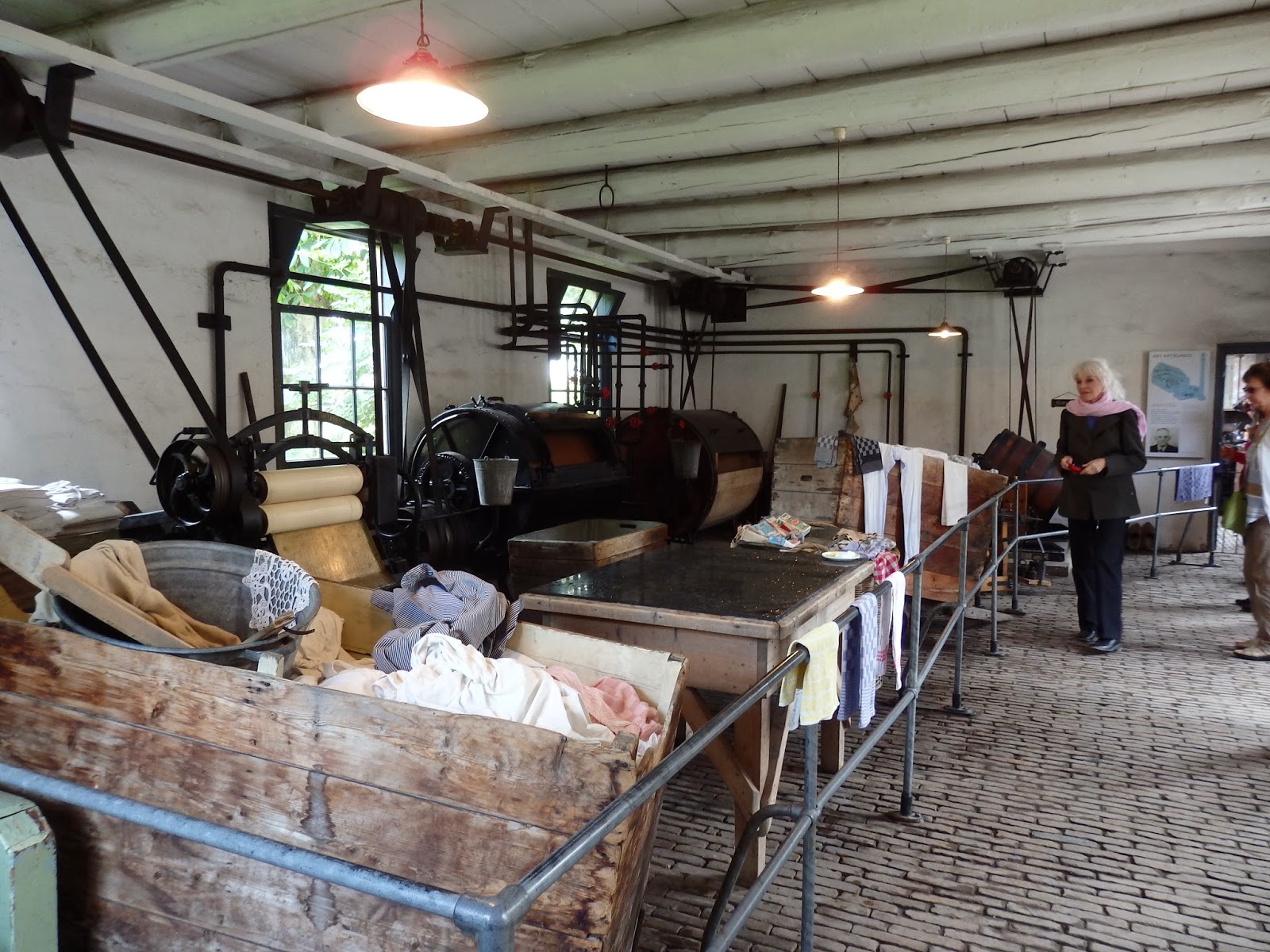
Hilbren explained that this open-air museum is similar to Williamsburg in the United States. And we did see a few people dressed in period costumes. They were working in some of the buildings and explaining their functions--i.e., the boiler/steam room, with the stoker who keeps the fire burning, which in turn drives the mechanism powering the laundry machines.


Doing laundry in the early 1900s was an amazingly detailed and time-consuming process, which a guy in that building explained. The soap-making, washing, rinsing, bleaching, stretching, pressing--overwhelming!

To find the most suitable houses for the museum village, staff members sent letters to all municipalities around the former Zuiderzee asking "if there were perhaps any buildings, large or small, earmarked for demolition, which could be regarded as characteristic of the former situation on the edges of the Zuiderzee." Many of the municipalities responded positively to this appeal; and only occasionally did the Museum actually have to buy a building. Most were donated.


Staff took into account the geographical origins, the function, and the social environment of each building, as well as the style, size, and façade within which the premises would be included. Streets, paths, ditches, and canals were assigned exactly the same dimensions as in their former situation. Historically-responsible paving, walls, and ground partitions completed the natural picture.


Various neighborhoods were created in this way: those around the church, the dike buildings, the town canal, and the fishing village, with a small polder between these last two. The Marken neighborhood (based on a copy of the Village of Marken), with the harbor, was the last neighborhood to be created.


Signs in front of each building explained what happened or who lived in the building. It was amazing what information has been culled from history and passed along to those who come after. These kilns burn shells from the North and Wadden Seas to create lime, which eventually is used in the manufacturing of cement.


We wandered and wandered through the little paths, over little foot bridges, and peeked into some shop windows. We entered the laundry, the church, the apothecary, and even flirted with some pigs who came running when I got close to the fence.


Last but not least, of course, the windmill is one of the mainstays of Holland's technological superiority in the Golden Age. They are used in paper-making, hemp-beating (a part of sail weaving), and pressing oil from linseed. In addition, they are indispensable in the impoldering of land or maintenance of the water balance. In all shapes and sizes, these old-fashioned wooden mills have nearly disappeared from the scene.

Monday, March 3, 2014

Maeslantkering Storm Surge Barrier and the Delta Project

Although this stop was a little mind-numbing for me--after all, we had been on and off the bus all day--I think the storm surge barrier was Sam's trip highlight. Hilbren had spent the day teaching us about the centuries-long struggle the Dutch have had with the seas. After the storm of 1953, they said "never again."
 

But the Netherlands exist in a low-lying Delta surrounded by water and the Port of Rotterdam must be accessible. So, how to solve the problem of and control storm surges? Six designs were submitted by companies within the Netherlands for the Delta Project--the barrier needed to be easy to maintain and not stop the flow of ships in and out of the port, even when there was fear of a surge. From those six companies, one was selected; and the barrier was installed in 1997.
 
Our group entered a grey metal industrial-looking building--the Keringhuis Museum labeled "Publiekscentrum Water--it looked more like a warehouse than a museum. But it held some interesting surprises. The huge photos, colorful layouts, and interactive displays were very impressive--in fact, critical for most of us to understand the concept. The very informed young man who was our guide explained in detail the history and workings of the barrier before we walked outside in the grey and windy weather.


If I understood correctly, this is how it works. As water rises--signaling a surge--the storm gates also rise, then shut, sinking to the riverbed and forming walls of steel. When storm season is over, the gates, which are open, sit on the docks to avoid corrosion--like they were today.

Every year on September 21st, they test the storm barrier by closing it (top photo), which is viewed by thousands who come out to watch. It stays closed for 12 hours so it can be examined and maintained. Since a major storm is expected only once every 10,000 years, I guess we'll never know if it will actually work! But what a lesson about how the Dutch survive living below sea-level.

Rebuilt Town of Zierikzee


Rebuilt after the catastrophic 1953 North Sea Flood, we stopped in Zierikzee to wander in the sun and find some lunch. What a beautiful day it was; we were lucky on this trip as far as weather went. After Hilbren gave us an introduction, we were free to take off, snap some photos, and find a place for lunch.


The town fronting the water was all rebuild since the flood, even though they kept the style of the original buildings.


We love these old drawbridges (this one, not so old) which are all over the Netherlands.


Fish and chips for lunch along the waterfront. What could be better? They were delicious and I ate too much (including an ice cream cone)!


And here's where we had our group photo taken, in front of the village's windmill.

Back on the bus and then a surprise stop at the North Sea.

The Netherland's Watersnood Museum


About 20 minutes from Bruges, we left Belgium and entered the Netherlands at Zeeland (translation," sea land"). Most of the land--a collection of islands--lies below sea level and was reclaimed over time from the sea, rivers, and lakes by the Dutch. In the process, the shape of the landscape has changed at the hands of both man and nature.

That's where the famous windmills enter into the picture. After diking off large tracts of land below sea level, the Dutch used those to harness wind energy, lifting the water up out of the enclosed area, diverting it into canals, and draining the land--called polders. They then cultivated hardy plants--like barley, followed by wheat--to remove salt from the soil, slowing turning marshy estuaries into fertile farmland. The windmills later served a second purpose for farmers by turning stone wheels to grind their grain.

 
Dutch reclamation projects are essentially finished. But in this era of global warning and rising sea levels, the Dutch are developing plans to upgrade their dikes and bulk up their beaches to hold back the sea. They also continue to innovate, building floatable homes and greenhouses (which rise with the tides) and relocating dikes farther from the rivers (to create wider floodplains). All this technological tinkering with nature over the centuries translated into a popular local saying: "God made the Earth, but the Dutch made Holland."
 

We finally--we drove for a couple hours, including a wrong turn because of construction--arrived at the town of Zierikzee and found the Watersnood (Flood) Museum in Ouwerkerk. This museum displays exhibits from the natural disaster which took place on the night of January 31, 1953 when the dykes gave way for a night of incredible flooding and mass destruction. Hilbren's uncle lived here at the time and swam all night to survive. Afterwards, he moved to Canada and never wanted to return because his memories were so traumatic.


Besides being dedicated to the North Sea Flood of 1953, the museum--which is located inside four massive breakwaters or caissons which were used to plug the last gap in the dike here--also shows how the Netherlands works with and against water, The caissons were from England and originally intended for one of the Allied landings at Ostend in Belgium, which was never realized.


For that reason, it was very cold in here--a very large exhibition "hall" full of exhibits, maps, books, records of the deceased, interactive displays, etc. We could've spent many hours educating ourselves but we only had about 45 minutes, much of which was taken up by watching a movie prior to wandering through the caissons.


Tens of thousands had to flee their homes that night; and 1,800 people lost their lives. The dreadful night obviously caused sheer devastation. But since that time, the Dutch government and people have worked to ensure this type of disaster never happens again. It was extremely sobering to see some of the remnants from the destruction to peoples' lives.


Next, we were headed to the rebuilt town of Zierikzee because the original one was damaged by the 1953 catastrophe.